Sapa Travel Map: Ultimate Guide, Top Attractions, Things To Do

Discover the Sapa travel map and the must-visit spots in this misty town in northern Vietnam. With its majestic mountainous landscapes, pleasant temperate climate, and the magic of experiencing four seasons in a single day, Sapa offers visitors a unique experience amid grandiose nature. To help you explore every corner of this beautiful region, the Sapa tourist map is a valuable tool for planning an itinerary tailored to your interests. Check out the Sapa map and helpful information below for an unforgettable and fulfilling trip!
Table of Contents
I. Overview of Sapa - The misty town in northern Vietnam
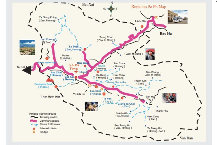
Where is Sapa on the Vietnam map? Sapa is a small town located west of Lao Cai province, north of Vietnam, bordering China. Nestled in a mountainous region, Sapa sits at an altitude of 1,600 meters above sea level. Additionally, it is home to Mount Fansipan, the highest mountain in Vietnam, and the “Roof of Indochina”, standing at 3,143 meters.
Sapa is also home to six ethnic groups: the Kinh, Hmong, Red Dao, Tay, Giay, and Xa Pho. These communities live in villages scattered around the town, such as Ta Phin village of the Red Dao, Cat Cat village of the Hmong, and Ta Van village of the Giay. The Sapa travel map allows you to explore these unique ethnic villages, each offering a fascinating glimpse into the region’s cultural diversity.

II. Suggested itinerary on Sapa tourist map
The travel map of Sapa below offers optimized itineraries between various tourist sites. Although some places are far apart, a smart organization of the stops allows this map to help you maximize your travel time while fully exploring this land of mist. Here are 5 recommended itineraries to easily navigate between attractions on the Sapa tourist map:
- Itinerary 1: Cat Cat Village – Ham Rong Mountain – Fansipan Mountain.
- Itinerary 2: Rong May Glass Bridge – O Quy Ho Pass – Silver Waterfall in Sapa – Cat Cat Village – Muong Hoa Valley – Muong Hoa River.
- Itinerary 3: Muong Hoa Valley – Fansipan Mountain – Cat Cat Village.
- Itinerary 4: Sapa Love Market – Sapa Stone Church – Sapa Lake – Ham Rong Mountain.
- Itinerary 5: Lao Chai Village – Ta Van Village – Giang Ta Chai Village – Ho Village.
III. Top attractions to visit on the Sapa travel map
The Sapa travel map is filled with iconic places to explore. From colorful ethnic villages to natural wonders, it offers a complete immersion into northern Vietnam. Here are some of the must-see sites in Sapa:
1. Fansipan Mountain
As the highest peak in Vietnam and the roof of Indochina, Fansipan attracts all travelers. At 3,143 meters above sea level, it is popular among trekking enthusiasts who come to admire the fairy-tale "sea of clouds". Those who prefer quicker access can take the cable car, which offers panoramic views of the primary forests and the Hoang Lien Son mountain range.

2. Rong May Glass Bridge
The Rong May glass bridge is a major stop on the Sapa travel map. Access it through a mountain tunnel and an outdoor elevator, then walk 60 meters above the void while enjoying the view of the mountains and rice terraces. Other thrilling activities such as zip-lining and wire biking are also available.
3. Muong Hoa Valley
Beautiful year-round, Muong Hoa Valley changes its appearance with each season. The green rice terraces in May and June give way to golden terraces in the autumn. The valley is also home to a field of ancient stones, with nearly 200 blocks engraved with mysterious patterns, classified as a national site.
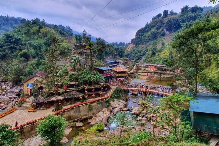
4. Cat Cat Village
On the Sapa map, Cat Cat Village is a perfect example of Hmong culture. This picturesque place invites visitors to discover the simplicity of daily life among the Hmong, surrounded by mountains and pristine forests. The name “Cát Cát” derives from the French word "cascade" which means waterfall, referring to the beautiful waterfalls in the village.
5. Ham Rong Mountain
In addition to Fansipan, Ham Rong Mountain is another symbol of Sapa. With its natural rock formations shaped like a dragon's head, this mountain also features beautiful flower gardens, creating a romantic atmosphere.
6. Sapa Ethnic Market
Held every Sunday, the Sapa ethnic market brings together the Hmong, Dao, and Giay minorities from surrounding villages. Here you can find handcrafted products such as embroidered fabrics and traditional clothing, as well as local specialties like "thắng cố" (horse meat), barbecue, and corn alcohol.
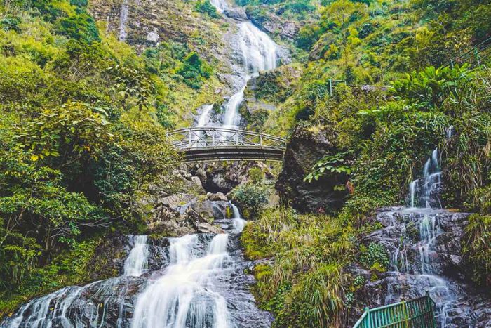
7. Sapa Silver Waterfall
Located near the O Quy Ho pass, the Silver Waterfall is another highlight on the Sapa travel map. They impress with their powerful flows cascading down the mountain. Visitors can relax in the stream below or climb the steps for a view from the top while enjoying fresh fish.
IV. Sapa Vietnam travel tips
For a smooth and memorable trip, here are some practical tips for consulting the Sapa travel map:
- Research transport options in advance, as tourist sites are often far from each other in Sapa. You can call a local taxi through your hotel reception or your homestay host, though this may take some time.
- If you’re driving yourself, be prepared to cross winding mountain passes in certain areas, which require good driving skills.
- Renting a car with a driver is a common option, especially if it’s your first time visiting Sapa. An experienced driver will allow you to explore tourist spots conveniently, safely, and without wasting time.
Here’s all the information on the Sapa travel map with itinerary suggestions to help you plan your stay. For additional details or any questions, feel free to contact Autour Asia, your Vietnam travel company, for prompt assistance!
The best time to visit Sapa is from September to November and from March to May. During these months, the weather is mild, with clear skies and stunning landscapes.
September and October showcase vibrant rice terraces ready for harvest, while March to May offers blooming flowers and pleasant temperatures. Avoiding the rainy season will enhance your experience, allowing you to fully enjoy Sapa's breathtaking scenery and unique cultural attractions.
A 3 to 4-day trip to Sapa is ideal for most travelers. This duration allows you to explore key attractions like Fansipan Mountain and the Muong Hoa Valley, as well as experience the local culture in ethnic villages such as Cat Cat.
You can also enjoy trekking opportunities and relax in the stunning landscapes without feeling rushed. However, depending on your personal preferences and requirements, you can adjust the itinerary accordingly. You can refer to: Sapa 3 days itinerary.
Related travel guide
Other similar articles
CUSTOMIZABLE BY LOCAL EXPERTS
Personalized trip at the original price!
REFUND GUARANTEE
We believe in our work and promise to give you money back.
GOOD PRICE / QUALITY
95% satisfied more than expected!
24/7 LOCAL SUPPORT
We are always available online to provide assistance at any time.
Most read articles
Autour Asia is highly recommended on
Embracing the mission of "Satisfied more than expected" and providing authentic experiences, we have received numerous recommendations on reputable travel forums:


